I see here that Baidu uses a custom coordinate projection system, which means it won’t work like a standard map source.
I can work on adding it in the upcoming week or two.
Regarding a timeline plugin, I can look into connecting queries to something like that as extra query operators; but does one of the timeline plugins offer some API to communicate with?
Something like Dataview integration to view map markers based on a range of dates by tags is definitely on the roadmap, and I can push it forward if it helps.
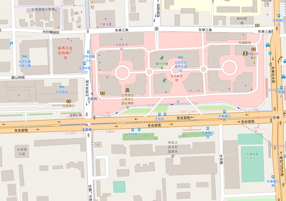
P.S: I’m far from an expert, but did you consider OpenStreetMap? It seems to be very detailed, don’t know if it’s Mandarin.
Hi @esm90,
Thanks for your prompt reply. It’s good to know that you can add Baidu Maps support. I’ve seen people discussing using Map View in China and it seems to be the no.1 request. This will definitely help lots of us for sure.
Meanwhile, I would like to try OpenStreetMap too (yes it’s in Mandarin Chinese).
Cons of OpenStreetMap could be (1) it’s not as detailed as Baidu and in some cases it’s a good thing because it makes the notes look tidier but you might not be able to pin some spots it misses. (2) Baidu updates the maps frequently but I don’t think OpenStreetMap can catch up in that regard so information can be outdated and incorrect in some cases (e.g. if you would like to use Map View to organise your trip).
As for the timeline, I haven’t tried any timeline plugins or Dataview so far (strange huh? everyone seems to use Dataview) because I want to keep my Zettelkasten system as simple and use as less non-native markdown syntaxes as possible. That said, being able to use Dataview with Map View to create a timeline-based map noting system is something big. Imaging a professional historian using this system to do his/her research and this will provide a fantastic three-dimensional tool to view a period of history.
Anyways, Iet me appreciate your work again for creating such a good plugin. I’ll start using it soon and might share some thoughts later.
Regards,
Acon
I had not really been looking for an alternative to leaflet, but in searching for some other info came across your plugin. It’s really amazing what you’ve created. I’m currently using it to mark locations for a Japan trip and you’ve made it so easy and yet extensible. …and fun. Quite an accomplishment.
I have but one question, can we localize a map? If we are somewhere without an internet connection, and hence no tile server, it would be nice to have the option of downloading a local map. To take my current example, I would determine a box of interest, let’s say wider Tokyo metro and a max zoom level. This is what I am used to for many iOS GPS apps from years ago. The map tiles get downloaded and otherwise the app would function as if connected.
What do you think? Or is there already a way to do this?
2 Likes
When I use inline link, the ‘(geo:)’ tern to emoji. Because ![]() is a emoji. What should I do?
is a emoji. What should I do?
I might miss something obvious, but what is the best way of having two map views showing different sets of locations?
I have a folder where I gather notes for my trip to the Artic, named “Artic 2023”, and have files like Places to visit.md, Where to eat.md, Nightclubs.md, and finally a file Places.md with the map. These have the locations: frontmatter and the geolinks in the respective files shows up on the map.
Now I want to plan my trip to Antartica next year, with similar setup. I would like to have a Places.md file with a map which only shows places of interest to that trip.
What is the best way to achieve this? I tried to play around with queries but did not come up with something that looked good. Do I need to set tags on all files in respective folder and use that for a query? I could not get path:"Arctic 2023/*" to work.
1 Like
First of all, thank you for this awesome plugin! I just discovered recently because my wife and I want to get better at logging our photography trips, and it is absolutely perfect for it.
I’m currently using it to document locations I’ve been to in France, and running into a quick or bug with how locations are displayed in embedded maps.
Context
I am documenting my trip in one long document (in my case called 2023-03_France.md), which contains quite a number of inline geolocation links (noteworthy things discovered along the way, such as a random viewpoint on a mountain pass) and also references external “global” geolocation notes (such as cities I’ve visited before but also visited on this trip, e.g. Paris). The map I’ve set up for this entry contains all entries from the trip log itself as well as any external notes linked in it (i.e., "query":"path:Travels/2023-03_France OR linkedfrom:Travels/2023-03_France/2023-03_France").
So far so good! I discovered something that I found surprising and could not find any documentation on, relating to how inline geolocation links are parsed. If this is not in fact a bug but just a feature quirk and it turns out I’m “holding it wrong”, that’s fine for me… I just need to get this off my chest & would be happy to help get this fixed, if it is indeed a bug ![]()
Issue: Display of inline link titles
I noticed that inline links that are displayed in the map always show the title of the document they are contained in, rather than the actual link title.
For example, in my 2023-03_France trip log, I am noting the hotel I stayed in:
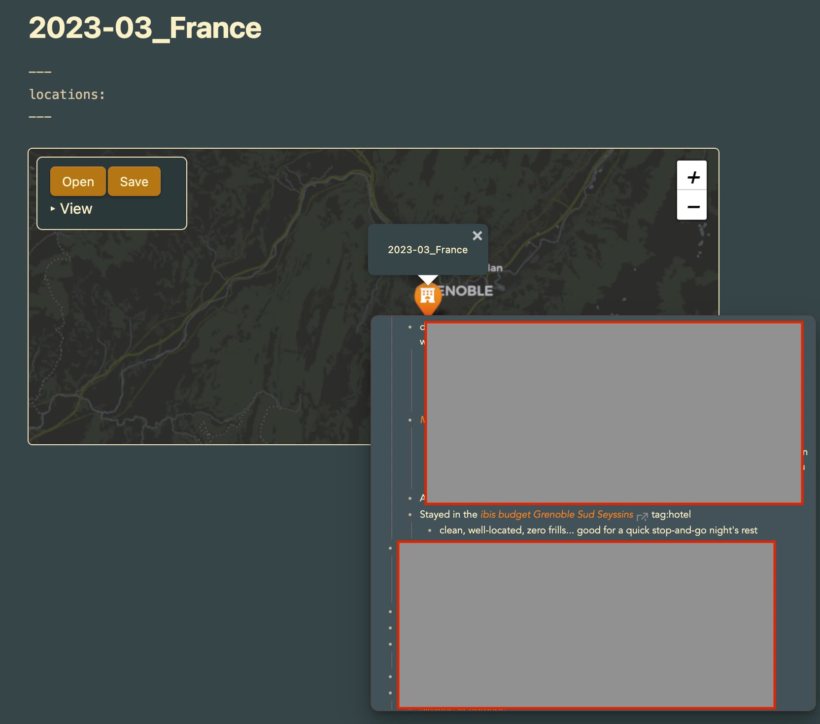
Screen shot: Hovering over the pin of the hotel, it shows “2023-03_France” as the pin title (which is the parent document – I would have expected that to read “ibis budget Grenoble Sud Seyssins”, which is the title of the actual link). As it is, I now have multiple dozen points (and counting) on the map all entitled “2023-03_France” and you have to read the popover highlight text to see what it actually is.
As mentioned above, I also have some external notes linked in the trip log (such as “Mont Saint-Michel”, where I have a number of detailed pins on photo spots, hiking trails, etc), and they all just show up as “Mont Saint-Michel” for all of their pin titles, which is only semi-helpful.
Do I have something configured wrong or is this actually a link display bug?
1 Like
Hi! Dows Map View support Publish?
thanks!
Marco
Hi.
I am also interested in timeline based map system. Have you found a way to make it happen?
Thank you for the plug-in. I have not yet installed it, but I plan to shortly. I’m using obsidian for knowledge retention of our operations. I have also discussed using it for creating story boards for fictional screen plays or books. I think it could be incredibly useful to be able to create “maps” or “3D maps” of whatever you choose. Say, your own house, an imaginary landscape, a business facility, equipment of a process or process block diagram? Map location/GIS data is insanely useful especially if you can get to precise or custom locations. There are many situations at work where I would love to zoom in on a process and click a piece of equipment and tie notes to it.
Out of curiosity, do you work at an oil refinery?
Thanks for creating an excellent plugin! One question… does this work with Google Places API (New) or strictly Google Places API? I tried the New API but no location queries were coming back.
Forgot to mention the difference:
Places API: Get detailed information about 100 million places.
Places API (New): Next generation of the Places API with access to more than 200 million places.
First of all, thank you for the excellent plugin.
Let me bother you to ask you some information.
I have many notes that contain geolocalizations (using the “geo:” method) some have only one link others more than one.
I would like, with a query or something else to show all the notes or get a list of coordinates showing all the points of “interest” near a given point. (To be inserted, indicated on the map or other way)
Let’s say I am in Rome and I have several notes with descriptions of monuments, museums, restaurants and I want a list of what I have around.
I don’t find the tags system particularly convenient for various reasons besides the fact that geolocated resources don’t always have tags or I may simply not remember the tags for useful research.
Also, I would like to export the information thus grouped into a new note or a format that allows me to quickly reference or prepare a paper document.
I am not a programmer, maybe the solution with a few lines of code already exists, in which case I apologize.
I thank you in advance for your help
Hello dear obsidian Map View community.
I have an issue, I don’t know if it’s a bug or a user mistake - I can’t add any map source. Or better said, if I add it, I can’t select it anywhere in the View Pane (or I can’t find it?)
For example, I add the Source Humanitarian, add the Url:
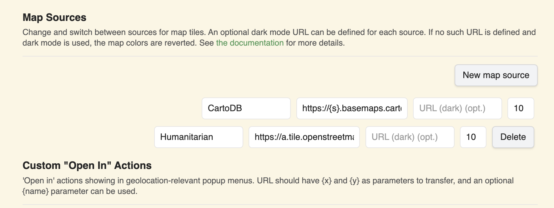
https://a.tile.openstreetmap.fr/hot/{z}/{x}/{y}.png, leave the Dark mode empty and put a zoom level of 19.
Even after restarting, I can’t select “Humanitarian” anywhere. See screenshots. What am I doing wrong?
Thank you for any advice, it would very appreciate. I love the Map View Plugin, and I really want to elevate it with custom Map ![]()
Map View 5.5.0
Obsidian Version 1.8.6 on Mac OS X 15.2
All the best, Félix
Edit: Turns out I was too silly to see that I minimized the control panel for months… There of course I can select the Map Layer.
This is super awesome - I have created a python script that takes in a json file (which conforms to a csv export from google maps “saved places” using google takeout, and converted with Claude.AI) and creates markdown files for each entry. You need to a google maps api key (free) as environment variable for it to work.
1 Like
You may have already resolved this, but if not, in my experience, that occurs when you have a space between the two numbers. There should not be a space after the comma.